Machine Learning-Equipped Drone for Early Detection of Wildfires
Introduction
California wildfires continue to have severe environmental, social, and economic impacts, causing billions of dollars in damage and displacing countless individuals each year. Although existing wildfire hazard systems and detection technologies help monitor fire activity, many rely heavily on historical data or only identify fires after they have already started. To address these limitations, our project develops a machine learning-based wildfire prediction system that aims to assess fire risk before ignition occurs. Using inputs such as temperature, humidity, and satellite imagery collected through drone technology, our model provides near real-time wildfire risk analysis. In addition, our user-friendly website allows users to easily access fire probability data and interactive wildfire risk maps for different regions. By combining automation, accessibility, and predictive technology, our project seeks to improve wildfire preparedness and help communities make more informed safety decisions.
Methods
The dataset, comprising approximately 5,750 fire and non-fire data points, was gathered through a systematic process. Every data point included a satellite image of the vegetation, the highest temperature of the day, and the humidity at the time. The data collection process was guided by the U.S. Department of Homeland Security's wildfire risk map. The tools we used for data collection were the Google Earth Pro app (satellite image), Wikipedia (fire information), and timeanddate.com / wunderground.com (temperature/humidity data). The drone cost $150, and the sensor was $50. We attached a SensorPush sensor to the drone using rubber bands to collect temperature and humidity data. The drone captures a bird's-eye-view image of the vegetation and sends it directly to our backend servers. After developing the model, we built a website that allows the user to input data and receive a fire risk probability for their location.
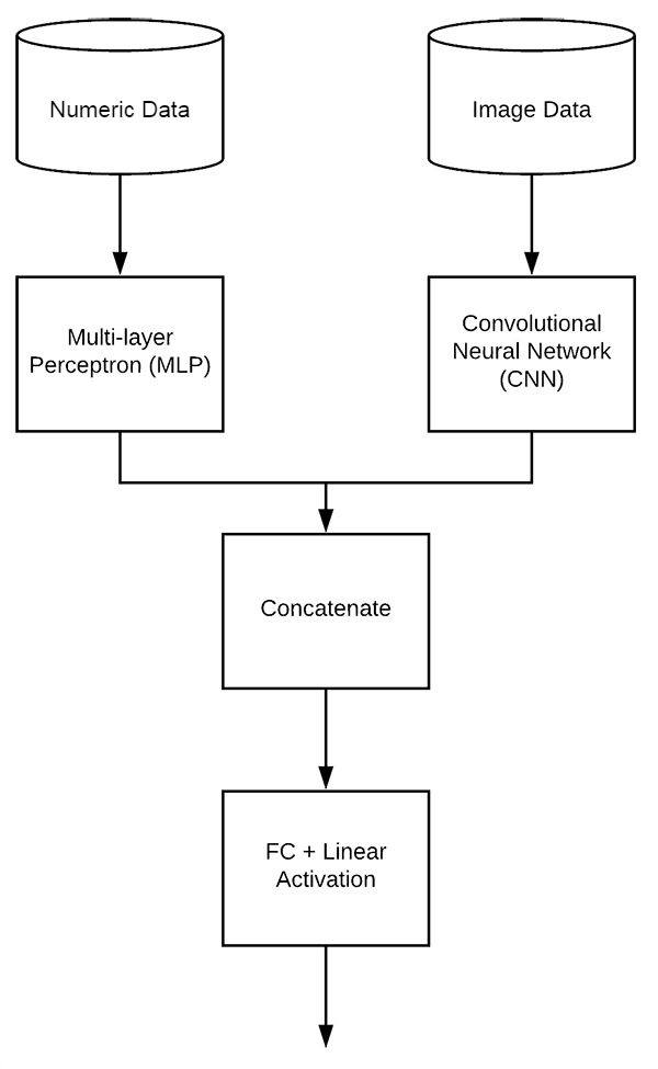
To create the machine learning model, we used Python's TensorFlow library, which offers a set of tools for building and training models. We created two separate model structures for the data, which consisted of temperature and humidity values, and image data, which is a satellite image of the vegetation. For the numeric data, we used a multilayer perceptron (MLP) because this type of model is effective at recognizing patterns in small datasets. For the image data, we used a convolutional neural network (CNN), a common architecture for image analysis. The outputs of these two models are then concatenated together and processed with a linear activation layer to produce the final result, which is the risk index of the data.
Results
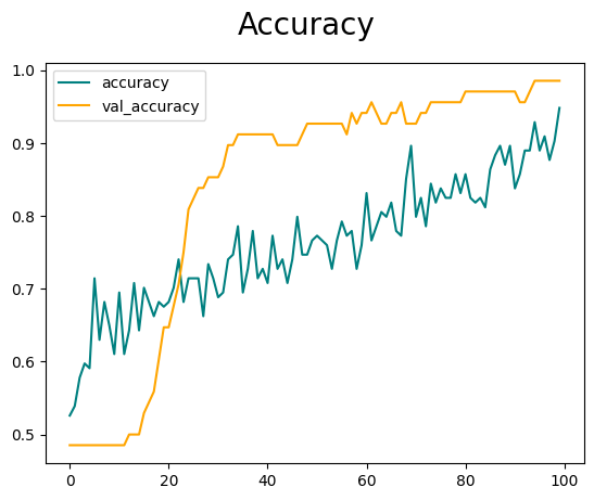
In validating our results, we utilized the National Wildfire Risk Index Map provided by the US Department of Homeland Security. The conclusion of our analysis revealed an impressive 91–92% accuracy for our model. Notably, as we expanded our dataset with additional data points, the model demonstrated an improvement in accuracy.
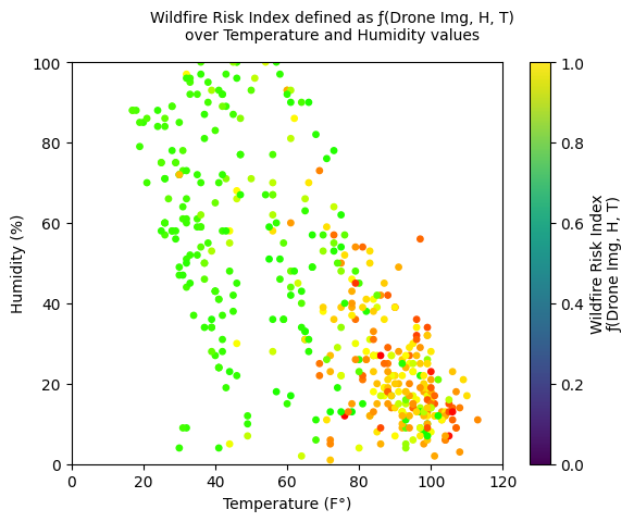
We collected 445 data points, each containing an image of the vegetation and temperature and humidity values. We entered these data points into our model, which produced a risk index for each point. The plot shows the correlation of risk index and temperature/humidity values. Overall, areas with high temperatures and low humidity tend to have higher risk indices. We can also see that the risk index of areas with similar temperature/humidity values can still vary, which suggests that the vegetation image captured by the drone also plays an important role in determining the final risk index.
We collected 94 data points consisting of a combination of drone and satellite images and plotted the risk index on a map of the Bay Area. Overall, the wildfire risk of the Bay Area at this time seems to be moderate. This is likely due to the current season, as wildfires occur more commonly around August. Our data is also quite consistent with the USDHS's map, with forests in the northern Bay Area having a relatively low risk index compared to the southern Bay Area.
Slideshow
If the slideshow does not load inline, you can open it directly here: Fire Detection Drone project - Lucas Su.pptx.pdf
Collaborators: Dale Liu, Pranav Saharan
2024